Ten Minute Block Coordinate Precision and Other Location Codes
Ten-minute Block Coordinate Precision
All banding and encounter locations stored in the BBL database are assigned coordinates as well as a "Coordinate Precision". This field must be considered when utilizing coordinate data provided by the BBL. The coordinate precision describes the coordinates by identifying them as exact, meaning the coordinates represent exactly where the bird was banded or encountered, or it defines the coordinates as encompassing a broader area, such as a 10-minute block or a state.
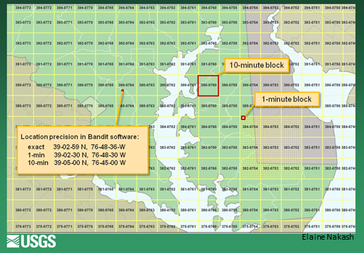
Most banding and encounter records stored in the BBL database have a coordinate precision of 10-minute block. A 10-minute block represents an area of 10 minutes of latitude by 10 minutes of longitude, so is a polygon (Figure 1). However, the BBL can only store the coordinate values of the center of the 10-minute block and the coordinate precision indentifies how the set of coordinates should be interpreted.
 |
|---|
| Figure 1. The area encompassed by different coordinate precisions: 10-minute block, 1-minute block, and exact. The 10-minute block highlighted in the image would have a Decimal Degree value of 39.08333 -76.08333 and a truncated Degrees, Minutes, Seconds (DMS) value of 390-0760. The box showing the exact coordinate value includes how exact DMS is converted to 1-minute and 10-minute block DMS. |
The coordinate values of all BBL records, regardless of the coordinate precision, may be provided in two formats. One is the Decimal Degree value* (e.g. 39.08333, -76.75) and the other is the truncated Degrees, Minutes, Seconds value* (e.g. 390-0764). When using the Decimal Degree value, one must consider the coordinate precision if they plot the data on a map. A Decimal Degree value that has a 10-minute block coordinate precision will plot in the center of a 10-minute block, not exactly where the bird was banded or encountered.
If the complete Degrees, Minutes, Seconds value needs to be translated from the truncated value provided by the BBL, add 5 to the minutes value and 00 to the seconds value (e.g. 390-0764 becomes 39 05 00, 076 45 00). When using this value, one must also consult the value in the Direction field, which indicates if the coordinates are NW, SW, etc.
Conversely, the truncated 10-minute block value can be determined by using the first three digits of the latitude followed by the first four digits of the longitude, using the initial zeros in all cases. For example, 39 degrees 03 minutes and 17 seconds N and 76 degrees 46 minutes and 55 seconds W would be coded as 390-0764. The latitude and longitude are not "rounded off" to the nearest 10 minutes but rather the last digit of the minutes and the seconds are dropped.
*Files from data requests provided by the BBL may have the Decimal Degree value labeled as LAT or LON FLOAT, LAT or LON DECIMAL, GISBLAT or GISBLONG. The truncated Degrees, Minutes Seconds value may be labeled as LAT or LON or LAT or LON 10 MIN BLK.
Other Location Codes
All Coordinate Precision Codes
Direction Codes (Worldwide 10-minute block corners)