Coordinate Precision Codes
| Code | Translation | Description |
|---|---|---|
0 |
Exact |
If a reporter provides coordinates with their report and they correspond to the description of the location, the exact coordinates they provided are retained on the report and this coordinate precision is used. It is also used if a reporter provides a description whose exact coordinates can be located on a map, such as a road intersection or an address. |
1 |
1-minute block |
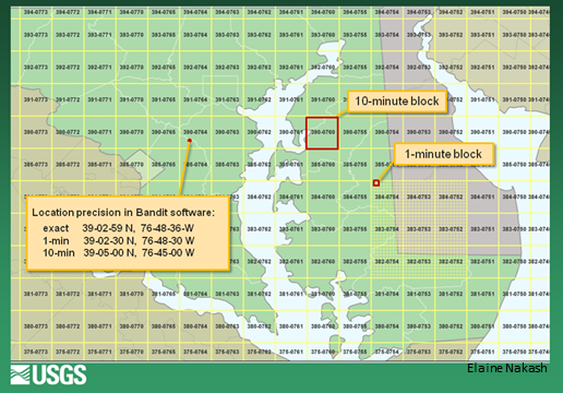
If a reporter provides a location description of a feature that is contained in the area of 1 minute latitude by 1 minute longitude, such as a pier or a community park, this coordinate precision may be used. The coordinates represent the geographical center of the 1 minute block. See Figure 1 below. |
10 |
10-minute block |
click here for detailed explanation |
7 |
County |
If a county is given for a location or the reported town cannot be found in the county or adjacent county, the coordinates of the geographical center of the county are used. |
11 |
Approximation based on centroid of town/place/area |
Coordinates represent the center of the town/place/area provided or were calculated using the distance and direction from the center of the town/place/area. |
12 |
State |
If, based on the location information provided by a reporter, a town or county cannot be located, the coordinates for the geographical center of the state may be assigned. |
8 |
Northwest of this point |
Codes 8,18,28, and 38 may occur in historical band encounter data but is rarely, if ever, used in modern data. In some instances, it was not possible to narrow the location to a ten-minute block, a county, or a single 1-degree block and the staff could best describe the area of the encounter with one of these codes. As an example for when code 8 was used, the hunter may have merely stated that he killed the bird in "Chesapeake Bay, Maryland" and failed to respond to subsequent requests for a more specific location. In these cases the intersection of the latitude and longitude lines nearest the southeast corner of "Chesapeake Bay" were determined. The state provided by the reporter, in this case Maryland, was assigned to the reports. |
18 |
Northeast of this point |
|
28 |
Southwest of this point |
|
38 |
Southeast of this point |
|
60 |
1-degree block |
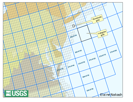
If a reporter provides a description, such as for a refuge, with no distance and direction from a town, that spans a large area, this coordinate precision may be used. For example, a hunter may indicate only that he shot a bird on Nezpique Bayou, Louisiana. This bayou extends into several 10-minute blocks and several parishes but is contained within a single 1-degree block. The coordinates of the center of the degree block that contains Nezpique Bayou are 303-0923. See Figure 2 below. |
33 |
Lat -10 min blk; Long-degree blk |
This coordinate precision exists primarily only in historical band encounter data and is rarely, if ever, used in modern data. Based on the location info that was provided by the reporter, the BBL staff at the time may have only been able to determine the county. However, due to storage limits in the computer system once used by the BBL, using the coordinates of the geographical center of the county and applying the county coordinate precision was not an option. Instead, the minutes of the longitude value were replaced with 7 to indicate only the county was known. In 2010 BBL staff needed to translate coordinates that might look like 384-0767, to valid coordinate values. The 10-minute block of the latitude was available but only the degree block of the longitude was known. Therefore, all records that previously had 7 in the longitude minutes value were assigned this coordinate precision. A record that once had 384-0767 would now have 384-0763. The encounter location occurred at this 10-minute block of latitude but could have been in 1 of 6 different 10-minute blocks of longitude. |
72 |
Country |
If, based on the location information provided by a reporter, a town, county, or state cannot be confidently determined, the coordinates for the centroid of the country may be assigned. This code is typically only used for countries outside of North America. |
 |
|---|
| Figure 1. The area encompassed by different coordinate precisions: 10-minute block, 1-minute block, and exact. The 10-minute block highlighted in the image would have a Decimal Degree value of 39.08333 -76.08333 and a truncated Degrees, Minutes, Seconds (DMS) value of 390-0760. The box showing the exact coordinate value includes how exact DMS is converted to 1-minute and 10-minute block DMS. |
 |
|---|
Figure 2. The area encompassed by a 10-minute block and a degree block are highlighted. A 10-minute block encompasses 10 minutes of latitude and 10 minutes of longitude. A degree block encompasses 1 degree of latitude and longitude, a total of 36 10-minute blocks. The degree block highlighted would have a Decimal Degree value of 39.5 -73.5, its geographical center, and a truncated DMS value of 393-0733. |