What is the BBS?
Get Involved
See Results
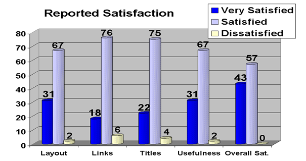
BBS Web Satisfaction Survey
[ back to the BBS News main page ]
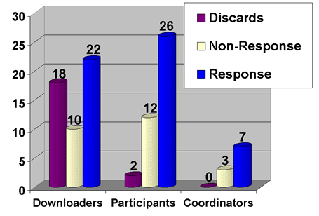
Sampling frame:
278 downloaders of raw BBS data in 2001
1,348 BBS participants
51 BBS coordinators
Random sample of:
50 downloaders, 40 participants, 10 coordinators
Discards are mostly students who have graduated
Non-response bias is smallSome of the requested additions to website:
- Information about the regions - climate, topography, land use patterns, etc.
- Precise stop locations (GPS).
- Digital maps of routes.
- Wish I could create my own strata, rather than using existing strata/states/bird conservation regions.
- Historical data on which years each route was run.
- Info about habitat types on a route (general categories, GIS coverages, change among years, etc.)
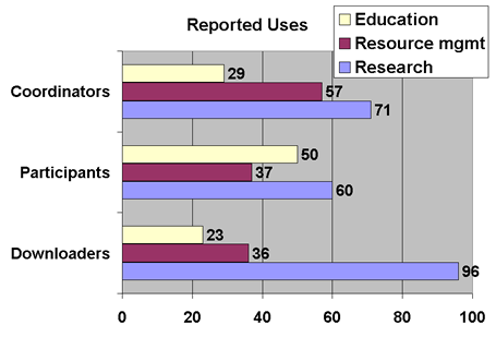
Some of the reported uses:
- To evaluate statistical methods in ecology.
- Comparing actual occurrences with modeled habitat, to test the models.
- To verify research priorities for my organization.
- Trend data and distribution maps are used to help make decisions about the importance of species as conservation in regional conservation planning.
- To provide an index of abundance to use as a covariate in other analyses.
- To assess risk of air strikes between birds and aircraft.
- Use it mostly for data entry of my 3 BBS routes.
- To gather info in order to write up species for Breeding Bird Atlas.
- I enter data and look at distribution maps for personal use.
- We manage migrant traps on Dauphin Island - trends are useful in helping us identify problem areas.
- Review my data for errors.
- Aid in participation in bird conservation initiatives, general information, outreach.
- I have used it as a source of population trend data to use in my dissertation.
Some of the suggestions:
- Homepage could make better use of white space (that is, spread things out a bit.)
- Icons or pictures might make the links more explanatory.
- Even having used the region level analysis before, I had to search to find it from the new opening page. If I had not known it existed, I would not have found it.
- It would be helpful to have a section for threatened & endangered species.
- Wish the trend estimates showed as soon as they come up without my having to scroll down a ways.
- Perhaps devising an easier method for finding specific route information would be helpful.
- It would be helpful to group routes and determine trends by bird conservation region.
- The BBS data entry web site is needlessly time consuming to use - in particular, do not make the data entry so dependent on little bits and pieces on each screen.
- Finding the physiographic strata base map is not intuitive, as it is buried in the help index.
A message from Keith Pardieck, project manager for the Breeding Bird Survey:
In June 2002, the BBS began collecting precise geographic location information for stops along BBS routes. The information is collected by BBS participants and entered into a stop location database. These data will be available for public use by June 2003 via the Raw Data link on the BBS web site. Accurate stop information in conjunction with remotely sensed habitat data could allow the BBS to generate habitat-specific trends, as well as be useful in answering questions regarding the validity of BBS results; such as, are habitats along BBS routes representative of habitats at broader geographic scales?
The BBS is also in the process of developing a stand-alone data entry program to supplement the web-based data entry program. The stand-alone program would be downloaded onto the user's PC allowing data entry to be completed without needing to stay connected to the Internet. Once data entry has been completed, the user simply sends us the data via email, the web, or a floppy disk.
We also plan to place a suggestion box on the BBS web site to allow users to keep us abreast of their changing needs or to suggest improvements to the site.
U.S. Department of the Interior | U.S. Geological Survey
Eastern Ecological Science Center Laurel, MD, USA 20708-4038
BBS Homepage
Contact Us
Last Modified: 2/5/2023
BBS Privacy Statement